In this update3
Full notes
Full TUNGUSKA: A Call in the Woods update
Read the full published notes in a cleaner layout. The original post stays linked below.
What changed
- Maps
- Gameplay
TUNGUSKA: A Call in the Woods changes
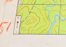
Scale and orientation
From the beginning to the end of the game, a map, as well as a compass, will be your primary navigation tool. Let’s start with the most important aspects that must draw your attention, no matter what kind of map you are using: scale and orientation.
Most maps in real life are oriented to the North direction. Meaning that the North is always directed toward the top of the map, and South - to the bottom, respectively. The directionality of the map is usually depicted as an arrow with an “N” symbol.
But even in our game, you may face maps with a different orientation. For example, it could be a sketch drawing of a particular place, made in a hussle, so the orientation of the map will have a direction that was convenient to the sketch’s author at that moment.
The second important aspect of any map is scale. Scale, to put it simply, is a relationship between distance on the map and distance on the ground. Usually, the map represents its scales both in numerical (as a ratio) and graphical (as a bar) forms, making distance measuring more convenient.
The Grid
Many maps also have a grid - a regular pattern of parallel lines intersecting at right angles and forming squares. Usually (but not always), the grid square side length equals scale bar length.
The grid helps you determine your location faster and more accurately, and it also can be used to quickly measure distance.
For more accurate distance measuring, you can use a ruler on the compass side while in Planning mode.
Another important feature of the grid is to give each point in the map an identifier, by which it can be referred to. For more precise addressing, a “by snail” technique is being used* - imagine a 3x3 grid inside a given square, with a list of numbers in a particular order. Using these numbers will help you to refer to a particular location more quickly and accurately.
*This technique (“ориентирование по улитке”, rus.) was used in the Soviet military so you may find something similar but with a different name in your country.
Custom notes
For highlighting points of interest, landmarks, and other objects, players can use a simple drawing system while in Planning mode.
We had a crazy thought to implement a “pen with a limited ink” feature but eventually rejected it.
We hope this entry was entertaining and valuable to our players. In the next Devlog, we will talk about what to do in case you are lost.
Thanks for your time!
Source
Changelog.gg summarizes and formats this update. How we read updates.